- Marine Geotechnics
- Cruises
- MSM119
MARIA S MERIAN 119
RV MARIA S. MERIAN - Expedition MSM119
St. John's, Canada - St. John's, Canada
(08.07 - 12.08.23)
Current Position of MARIA S. MERIAN
MARIA S. MERIAN with German Research Fleet Coordination Centre
Weekly Reports
Overview - Expedition to the Reykjanes Ridge
The northeast Atlantic is the destination of expedition MSM119 with the research vessel MARIA S. MERIAN. The seafloor drilling rig MARUM-MeBo70 is also on board. The aim is to drill into the upper ocean crust of a young, cold flank of the Mid-Atlantic Ridge and to install borehole observatories. In the future, they will be used to document and quantify the fluid flow in the basaltic crust.
The work will be realized in the context of the MARUM Cluster of Excellence "Ocean Floor" as well as the DAM research mission "CDRmare" (there the project AIMS3). Already last year, researchers explored sedimentary basins at the southern tip of the Reykjanes Ridge during a scientific expedition (Expedition M183).
The scientific program mainly aims to drill through the complete sediment sequence with the MARUM MeBo70 drill rig and then drill several meters into the oceanic upper crust. This will happen along a transect connecting the cooler side ("recharge") of Squid Pond with the warmer side ("discharge").
The main scientific tasks include determining the variation of pore water composition with depth and characterizing effects in the sediment and pore water. In this way, conclusions can be drawn about fluid circulation in the upper part of the young ocean crust.
Complementary to core recovery with MeBo, basaltic samples will be sampled at the ridge axis. Additional measurements of the temperature distribution in Squid Pond will be taken using a gradient lance or sensors on the heavy plummet.
Participating institutions:
- MARUM - Center for Marine Environmental Sciences, University of Bremen
- Department of Earth Sciences, University of Bremen
- Alfred Wegener Institute Helmholtz Centre for Polar and Marine Research
- Department of Earth and Planetary Sciences, Harvard University
Synopsis
Based on cruise M183 (2022), which explored sedimentary basins in the area of the eastern flank of the southernmost tip of the Reykjanes Ridge, the MARUM MeBo70 seafloor drill rig will be deployed on expedition MSM119. The planned research will investigate the relevance of hydrothermal circulation in the flanks of oceanic ridges, and in particular of young basaltic crust with low sediment cover on the Reykjanes Ridge south of Iceland. The global importance of these circulation systems for the exchange between the crust and the oceans as well as the deep biosphere and their role in the carbon cycle will be assessed by drilling, sampling, and monitoring locations of seawater inflow and outflow in cool and warm regions of the Squid Pond.
The work will take place in the context of the MARUM Cluster of Excellence "Ocean Floor" and the DAM research mission "CDRmare" (project AIMS3).
Scientific Programme
The primary objective of the scientific programme is to drill through the complete sediment sequence with the MARUM MeBo70 seafloor drill rig and then drill a few tens of metres into the oceanic upper crust. This will be done along a transect connecting the cooler side ("recharge" site) of Squid Pond with the warmer side ("discharge" site). The main scientific tasks include determining the variation of pore water composition with depth and characterising diagenetic effects in the sediment and pore water. In this way, conclusions can be drawn about the fluid circulation in the basement (altered, upper part of the young ocean crust).
Complementary to core recovery with MeBo, basaltic samples will also be sampled closer to the ridge axis using dredges. Additional measurements of the temperature distribution in Squid Pond will be taken using a gradient lance or sensors on the gravity corer.
Work Programme
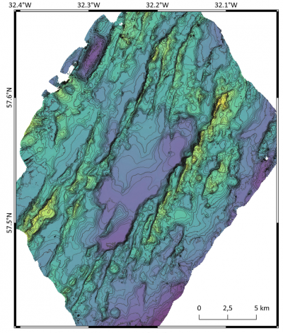
From the previous cruise M183, high-resolution sediment thickness maps of Squid Pond are available from marine echo sounder data (EM122) and hydroacoustic PARASOUND profiles, based on which three drilling locations for MeBo70 seafloor drill were determined. The work program for each of these boreholes is to:
(1) Coring of the sediment cover from seafloor to upper ocean crust to perform core description/and sample the material for further shore-based analysis.
(2) On the fresh cores, sediment oxygen concentrations are measured with needle optodes or microelectrodes (to determine microbial oxygen respiration in the sediment and the potential for diffusive oxygen flow from the subsurface to the overlying sediment).
(3) The sediment pore water is then sampled in the cold room with rhizone samplers and stored for post-trip analysis.
(4) The deep cores with altered basaltic upper ocean crust will also be logged and stored onshore for mineralisation experiments.
(5) After the terminal drilling depth is reached, enough MeBo drill rods are retrieved from each of the boreholes to ensure that the sediments remain cased in the long term and that a passage to the deep borehole is maintained. Afterwards, a borehole observatory is mounted by the MeBo and the instrument returns on board.
The work programme for the times when MeBo is on deck includes sampling with a gravity sounder, temperature gradient measurements and dredging of basaltic surface rocks near the ridge axis.
In addition, the deployment of a deep-sea lander is planned, which, just like the borehole observatories, will record various physical and chemical parameters over the next two years.


