
Page path:
- Home
- Infrastructure
- Marine Technology
- NERIDIS Electromagnetic Seabed Profiler
- NERIDIS OPERATION
NERIDIS OPERATION
The benthic profiler NERIDIS III (‘Neritic Discoverer’) is a MARUM-built Bottom Towed Vehicle. It bundles a small range of complementary high-resolution techniques, which must operate very near the seafloor (benthic profiling) to reach their objectives. In the case of optics, distance limitation is clearly related to the dispersion of light in sea water. Sharp images require short distance and relatively clean water. In potential methods, the sensor’s distance determines the size and spacing of objects, which can be identified and isolated. Due to the better conductivity of seawater relative to sediment, electromagnetic seabed characterization necessitates a low and relatively stable distance between sensor and sediment. The ground offset and penetration depth of the extremely sensitive concentric coil approach to EM is coupled to the size of the transmitter coil.

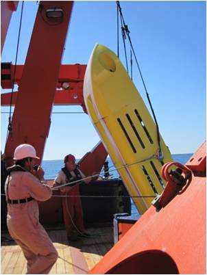
Deployment and Recovery
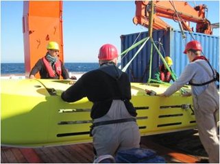
Deployment procedure:
- lifting the GEM Shark profiler above the center of gravity by means of a bridle
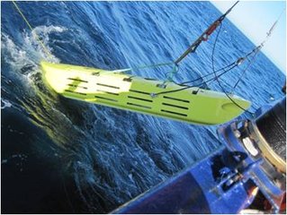
- disembarkation of the profiler to the sea-surface, releasing the bridle and slacking the tow-cable
- when flooded, the profiler sinks with a ~15° pitch angle and lands on the seafloor at a tow-cable length of about 2.5 times the water depth
- stable bottom contact profiling is assured at about 3 knots (s.o.g.) and a tow angle of about 20° (indicated by <2° oscillation of pitch, roll and heading)
- recovery via tow line.
Data Acquisition

- Real-time communication via tow-cable DSL.
- Labview data acquisition and real-time visualization environment.
- Positioning from the ship’s DGPS position, cable length, water depth and heading.
- Time synchronization via GPS TTL signal.
Motion Characteristics

Two skids provide a steady course (typically ± 1°) and low pitch (± 2°) and roll (± 1°) angles. A stable dive and soft landing is achieved by adjusting winch slack to ship speed. Stable ground contact (zero pitch) can be maintained at tow speeds of 2-4 knots. The tow cable length is dynamically adjusted to about 3.5 times water depth.
Left: 1st 5 min of bottom surveying
Collision Avoidance and Rescue Concept

Profiling surveys are typically accompanied by shipboard Multibeam bathymetry for obstacle avoidance.
In the case of collision with large obstacles, a break point at the bow releases the tow cable. The loss of communication causes an integrated flotation system to inflate two 250 kg lift bags in bow and stern after a pre-defined delay-time. The profiler can be recovered at the sea surface or by a trailed Kevlar safety line with head buoy.
In the case of collision with large obstacles, a break point at the bow releases the tow cable. The loss of communication causes an integrated flotation system to inflate two 250 kg lift bags in bow and stern after a pre-defined delay-time. The profiler can be recovered at the sea surface or by a trailed Kevlar safety line with head buoy.