- Home
- Discover
- Media Releases
- Media Releases 2020
- Rainforest West Antarctica
Traces of rainforests in West Antarctica

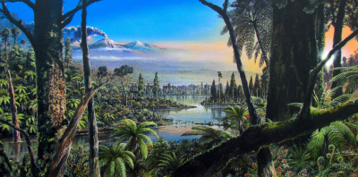
These plant remains confirm that, roughly 90 million years ago, the coast of West Antarctica was home to temperate, swampy rainforests where the annual mean temperature was about 12 degrees Celsius – an exceptionally warm climate for a location near the South Pole. The researchers surmise that this warmth was only possible because there was no Antarctic ice sheet and because the atmospheric carbon dioxide concentration was significantly higher than indicated by climate models to date. The study, which provides the southernmost directly assessable climate and environmental data from the Cretaceous and poses new challenges for climate modellers around the globe, was now published in the journal Nature.
The mid-Cretaceous time interval, from about 115 million to 80 million years ago, is not only considered the age of the dinosaurs, but was also the warmest period in the past 140 million years. Sea surface temperatures in the tropics at this time were likely as high as ca. 35 degrees Celsius, and sea level was 170 metres higher than today. Yet we still know very little about environmental conditions in the Cretaceous south of the polar circle, since there are virtually no reliable climate archives that extend that far back in time. The new sediment core offers the team of experts the first chance to reconstruct the West Antarctic climate during the warmest interval of the Cretaceous, thanks to the unique evidence it contains.
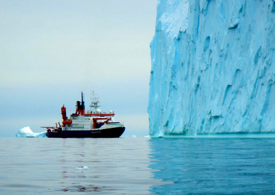
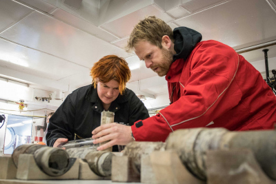
In the sediment core, which the team collected with the University of Bremen’s seafloor drill rig MARUM-MeBo70 near the Pine Island Glacier on an RV POLARSTERN expedition, they found pristinely preserved forest soil from the Cretaceous. “During the initial shipboard assessments, the unusual colouration of the sediment layer quickly caught our attention; it clearly differed from the layers above it. Moreover, the first analyses indicated that, at a depth of 27 to 30 metres below the ocean floor, we had found a layer originally formed on land, not in the ocean,” reports first author Dr Johann Klages, a geologist at the AWI.
Evidence of a swamp landscape rich in vegetation
Yet it didn’t become clear just how unique the climate archive truly was until the sediment core was subjected to X-ray computed tomography (CT) scans. The CT images revealed a dense network of roots that spread through the entire soil layer of fine-grained clay and silt, and which was so well-preserved that the researchers could make out individual cell structures. In addition, the soil sample contains countless traces of pollen and spores from various vascular plants, including the first remnants of flowering plants ever found at these high Antarctic latitudes.
“The numerous plant remains indicate that 93 to 83 million years ago the coast of West Antarctica was a swampy landscape in which temperate rainforests grew – similar to the forests that can still be found, say, on New Zealand’s South Island,” explains co-author Prof Ulrich Salzmann, a palaeoecologist at Northumbria University in Newcastle upon Tyne.
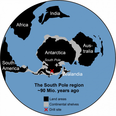
The results of the vegetation analysis puzzled the researchers: under what climatic conditions could temperate rainforests have formed back then at a geographic latitude of roughly 82 degrees South? Even during the Cretaceous, the Antarctic continent was at the South Pole, which means the region where the forest soil originated was subject to a four-month polar night; for a third of every year, there was no life-giving sunlight at all.
“To get a better idea of what the climate was like in this warmest phase of the Cretaceous, we first assessed the climatic conditions under which the plants’ modern descendants live,” says Johann Klages. The researchers subsequently searched for biological and geochemical temperature and precipitation indicators in the soil sample, on the basis of which they could reconstruct the air and water temperature in the West Antarctic rainforests, as well as the amount of precipitation they received.
Numerous analyses, one result: In the Cretaceous, Antarctica was ice-free and extremely warm
The outcomes of the various analyses fit together like the pieces of a puzzle: Roughly 90 million years ago, there was a temperate climate just 900 kilometers from the South Pole. The annual mean air temperature was about twelve degrees Celsius; in other words, back in the Cretaceous, the average temperature near the South Pole was roughly two degrees warmer than the mean temperature in Germany today. Summer temperatures were about 19 degrees Celsius on average; water temperatures in the rivers and swamps reached up to 20 degrees; and the amount and intensity of rainfall in West Antarctica were similar to those in today’s Wales.
The researchers then used this new vegetation, temperature, and precipitation data from West Antarctica as target values for simulations of the mid-Cretaceous climate. Their calculations with a palaeoclimate model revealed that the reconstructed conditions could only be achieved when (1) the Antarctic continent was covered with dense vegetation, (2) there were no land-ice masses on the scale of an ice sheet in the South Pole region, and (3) the carbon dioxide concentration in the atmosphere was far higher than previously assumed for the Cretaceous. “Before our study, the general assumption was that the global carbon dioxide concentration in the Cretaceous was roughly 1000 ppm. But in our model-based experiments, it took concentration levels of 1120 to 1680 ppm to reach the average temperatures back then in the Antarctic,” says co-author and AWI climate modeller Prof Gerrit Lohmann.
Accordingly, the study shows both the enormous potency of the greenhouse gas carbon dioxide, and how essential the cooling effects of today’s ice sheets are. “We now know that there could easily be four straight months without sunlight in the Cretaceous. But because the carbon dioxide concentration was so high, the climate around the South Pole was nevertheless temperate, without ice masses,” explains co-author Dr Torsten Bickert, a geoscientist at the University of Bremen’s MARUM.
The big question now is: if it became so warm in the Antarctic back then, what caused the climate to subsequently cool so dramatically to form ice sheets again? “Our climate simulations haven’t yet provided a satisfactory answer,” says Gerrit Lohmann. Finding the causes of these tipping points is now a key challenge for the international climate research community.
Klages, J.P. et al: Temperate rainforests near the South Pole during peak Cretaceous warmth, Nature, DOI: 10.1038/s41586-020-2148-5
Background on the publication:
The sediment core analysed in the study was collected in the Amundsen Sea during the German polar research vessel POLARSTERN’s expedition PS104. This was accomplished with the seafloor drill rig MARUM-MeBo70, which was developed at MARUM in Bremen and used for the first time in the Antarctic. The X-ray computed tomography (CT) scans were conducted at the Klin-ikum-Mitte hospital in Bremen.
Participating institutions:
• Alfred Wegener Institute, Helmholtz Centre for Polar and Marine Research (AWI), Bremerhaven
• Northumbria University, Newcastle upon Tyne, Great Britain
• MARUM – Center for Marine Environmental Sciences, University of Bremen
• British Antarctic Survey, Cambridge, Great Britain
• Faculty of Geosciences, University of Bremen
• Imperial College London, Great Britain
• University of Southampton, Great Britain
• Institute of Geosciences, Kiel University
• Institute for Geophysics and Geology, Leipzig University
• Polish Academy of Sciences, Krakow, Poland
• Department of Geology, Trinity College Dublin, Ireland

