- Home
- Deutschland Tour 2021
- Stage 3. Ilmenau – Erlangen
Stage 3. Ilmenau – Erlangen
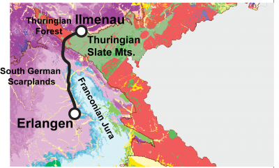
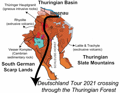
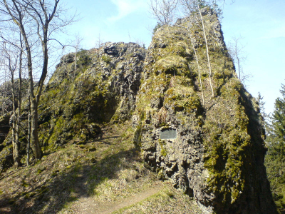
After a good night’s sleep in Ilmenau, the riders ascend out of the Thuringian Basin into the Thüringian Forest. More specifically, the Deutschland Tour is crossing through the Oberhof trough, which is the largest and easternmost geologic part of the Thuringian Forest. Just like the Thüringian Basin, the Oberhof through is an uplifted geologic basin. However, this pile of dishes has been disturbed by tectonics and vulcanism to such an extent that it is much more difficult to reconstruct the relationships and hierarchies between the different rock layers. What we do know, however, is that the riders pass over two distinctly different types of volcanic rocks: Granite rocks that slowly cooled and solidified underground and volcanic rocks that rapidly cooled when hot magma flowed out onto the Earth’s surface or solidified in volcanic corridors close to the Earth’s surface (rhyolites, latites and trachytes). The latter rocks belong to the so-called Rotliegend Group. They are the silent witnesses of the intense volcanism around 300 million years ago that occurred when different continental plates collided, subducted, and ultimately formed the Pangea supercontinent. The granite rocks are a little bit older, around 320 million years old. The Thüringian Forest granite thus forms the foundation for the oldest layers of the somewhat younger Rotliegend Group accumulating on top. Near the village of Frauenwald, the cyclists come very close to the oldest rock formation that will be discussed in this Deutschland Tour 2020 series: The Vesser Complex of Cambrian age (~500 million years old) that appears on the geologic map as an island of marine sedimentary rock within a large area that is dominated by volcanic rocks. In fact, the Vesser Complex belongs to the Thuringian Slate Mountains, rather than to the Thuringian Forest, but due to the complicated tectonic history and the many faults in the region, they come to the surface here.
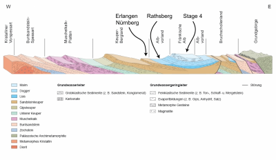
Once out of the Thuringian Forest, the riders get into the South German Scarplands. First, the riders encounter the same Triassic sedimentary sequence that they already found in the Thuringian Basin in Stage two: The alluvial fans of the Bundsandstein that formed at the time of supercontinent Pangea, the Muschelkalk limestones that formed in a marine environment when Pangea was rifting apart in several smaller continents and the basin in-between was flooded by sea water, and finally the Keuper layers that were deposited when the sea level went down again again and allowed for the deposition of salts, anhydrites, gypsum, submarine fans and continental floodplain deposits.
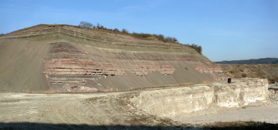
Then, between Coburg and Sesslach, the riders advance another few million years in time, ending up in the Jurassic, and moving through another episode of sea level rise. Today’s Jurassic excursion is however of limited extent as this third stage mostly avoids the topographically somewhat higher-positioned Franconian Jura. Instead, the riders race to Erlangen mostly on top of Triassic Keuper strata. The Frankonian Jura is the backdrop for the fourth and final stage, and will be described tomorrow in much more detail. To understand today's arrival, though, it is necessary to look at the geologic build-up of the Rathsberg in Erlangen. Here, we find coarse-grained Keuper sandstones at the base, but these give way to chalky marl layers from the Jurassic at the top of the hill. So before arriving at the finish, the riders go through the same episode of sea level rise once again, from the Triassic into the Jurassic! Remains to be seen who has left some dinosaur power in his legs to win this third stage… My guess is that John Degenkolb will be the fastest of the pack today.
