Page path:
- Home
- Infrastructure
- Marine Technology
- NERIDIS Electromagnetic Seabed Profiler
- NERIDIS VEHICLE INFORMATIONS
NERIDIS VEHICLE INFORMATIONS
System outline
The benthic profiler NERIDIS III is a marine electromagnetic profiler that has been developed for coastal and shelf operations in up to 500 m water depths. The system was designed to resolve subtle and gradual variations in silt and clay content, magnetic mineral concen-tration (e.g. titanomagnetite black sand), porosity and diagenesis state of marine sediments at a sub-meter scale.
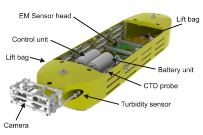
Figure on the right: a CAD image of NERIDIS III profiler with open lid to show arrangement of control and battery units, EM sensor coil, CTD, recovery system and new high resolution still camera.

System specification
| Type | MARUM build bottom towed vehicle |
| Depth rating | 1000 m (operated in 450 m off NW Spain) |
| Weight | 900 kg (in air), ~250 kg (in water) |
| Dimensions (L x W x H) | 5.2 x 1.2 x 0.8 m |
| Power | 2x 40 Ah Lithium Ion Battery Packs à 24V and 12V |
| Telemetry | SHDSL (armored coax cable) or Ethernet |
| Tow cable length | ~3.5 times water depth (~20° tow angle) |
| Tow speed | 2 - 4 knots |
| Scientific payload | - Frequency Domain EM (1m transmitter and concentric-coaxial receiver coil) - Conductivity-Temperature-Depth and Turbidity probe - Motion control (heading, roll, pitch, 3D acceleration) - Camera and video observation - Digital color macro photography (5 MP, 5 fps, 200 micro-s) - Gammaray spectroscopy (Medusa MS SUB) - in prep. |
| Sampling rates | EM (25 Hz), CTD (10 Hz), motion (50 Hz), Photo (5 fps) |
| Application | - Bottom towed (ground contact) by mid-size or large research vessels - Integrated flotation system (e.g. transit and recovery) - A-frame or crane deployment - Real time data via tow cable |
| Mission durations [max distance] | ~ 12 h or ~7 h incl. Photography [80 or 45 km respectively] |
| Modular concept | Sensor configuration is based on 3-8 specific modules (each module provides a loading space of 0.7 x 1.2 x 0.5 m - length x width x height) Specific modules can be designed to meet custom needs |
CSEM Imaging Concept

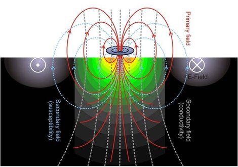
The non-magnetic and non-conductive NERIDIS III fully encases a state of the art broadband frequency domain EM sensor with horizontal coplanar arrangement of concentric 96 cm transmitter, bucking and receiver coil (modified and marinized Geophex GEM-3). Superimposed frequencies of the transmitted waveform between 25 Hz and 20 kHz allow to determine target specific EM spectra (UXO, cables, ferrous objects) and the magnetic susceptibility and electric conductivity of the sub-surface. Measurements are performed at sampling rates up to 25 Hz (approx. 0.1 meter resolution at 4 kn speed).
Optical Imaging Concept

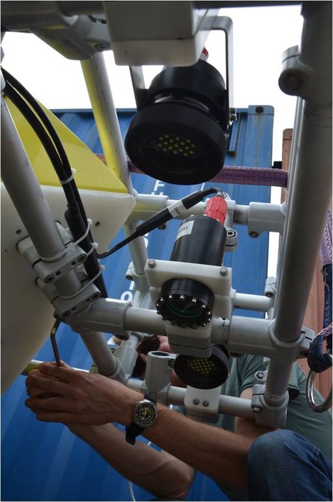
The optical imaging concept is based on a AVT Prosilica GC2450C high-speed industrial quality digital color camera (5 frames per second, 5 Megapixel) and electronic high-speed shutter. Two rugged high-performance LED flash units synchronized with the camera shutter will permit rapid flashing with exposure times of a few µs.
| Camera type | Prosilica GC2450C (5 MP, up to 15 fps, 2448 x 2050) |
| Flashes | 2x 24 LED Cree flashes (4 channels à 8 A each) |
| Data recording | DFKI rock environment on Linux PC with 500 GB SSD |
| Optical resolution | 1900 x 1900 pixel over an area of 40 x 40 cm; sub-mm resolution |
| Illumination time (at 3.5 kn tow speed) | 100 - 200 µs |
| Data volume per km | 10 GB / km |
| Inspection | Low resolution jpg's at desired time intervals |
The availability of sharp and numerous images offers many research opportunities from object/specimen counting over ripple analysis to habitat mapping and sediment identification by automatic algorithms. At track crossings, these photos even permit to detect, evaluate and (hopefully) exclude eventual seabed scouring by the operation of the EM profiler itself.


