Page path:
- Home
- Research
- Ocean and Climate
- Projects & Collaborative Groups
- RACE
- Theme 2
- WP 2.2: The variable ocean circulation at the western margin of the subpolar North Atlantic
WP 2.2: The variable ocean circulation at the western margin of the subpolar North Atlantic
PIs:
Johannes Karstensen, GEOMAR Kiel, jkarstensen(at)geomar.de
Martin Visbeck, GEOMAR Kiel, mvisbeck(at)geomar.de
Inga Koszalka, GEOMAR Kiel, ikoszalka(at)geomar.de
Team:
Patricia Handmann, GEOMAR Kiel
Rainer Zantopp, GEOMAR Kiel
Jürgen Fischer, GEOMAR Kiel (beratend)
Johannes Karstensen, GEOMAR Kiel, jkarstensen(at)geomar.de
Martin Visbeck, GEOMAR Kiel, mvisbeck(at)geomar.de
Inga Koszalka, GEOMAR Kiel, ikoszalka(at)geomar.de
Team:
Patricia Handmann, GEOMAR Kiel
Rainer Zantopp, GEOMAR Kiel
Jürgen Fischer, GEOMAR Kiel (beratend)

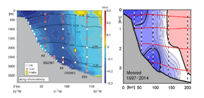
Fig. 1 caption: The 53°N Array at the exit of the Labrador Sea, superimposed on mean flow from 17 years of moored current measurements compared to shipboard LADCP measurements.
At the exit of the Labrador Sea, near 53°N, the various components of the deep water circulation have merged into the Deep Western Boundary Current (DWBC).
Extended time series of temperature, salinity and currents have been collected as part of the “53°N Array” since 1997 which permit the analysis of transport fluctuations and hydrographic structure on timescales from hours to decades.
In RACE I we demonstrated that transport fluctuations with periods of a few days are due to topographic waves, and that the transport in the deep part of the DWBC, underneath the Labrador Sea Water (LSW), is dominated by fluctuations in the 8-10 year range. Quite unexpectedly we find that that this multi-year fluctuation is only evident in the deep portion of the DWBC while the LSW transport shows a rather weak signal.
In RACE II we will investigate the regional coupling between transport, thermohaline and wind-forced fluctuations by analyzing the moored observations and modeled time series. By 2017, the planned continuation of the 53°N Array will provide two decades of high-quality time series. Our work is embedded in the transatlantic OSNAP (Overturning in the Subpolar North Atlantic Program) that aims to determine the basin-wide overturning transport in the subpolar gyre on time scales of days. The 53°N array is an integral part of the OSNAP array.
Another aspect of our planned activities is the future-oriented optimization of the moored array by using a joint analysis of observations and ocean modeling data.


